Sugar Palm Tree by Asienreisender

Sugar Palm Trees. Typical for rural Cambodia. Image by Asienreisender, 2013

Around Yaklom Crater Lake by Asienreisender

The inconspicious path around Yaklom crater lake. Image by Asienreisender, 2013

Dragon Painting in Wat Aran, Ban Lung, Ratanakiri by Asienreisender

A dragon painting on a pillar in Wat Aran, Ban Lung. Image by Asienreisender, 2013

Boiled Snales by Asienreisender

Boiled snales, sold as snack in Ban Lung. Image by Asienreisender, 2013

Snales for Sale by Asienreisender

The snales in detail. More often are river clams for sale on the markets. Image by Asienreisender, 2013

Jungle Tree by Asienreisender

One of the jungle trees, remaining isolated from the bygone forest. Image by Asienreisender, 2013

Suspension Bridge over a San River Tributary by Asienreisender

A suspension bridge over a tributary of the Tonle San at Ban Taveng. Image by Asienreisender, 2013

The Road between Ban Lung and Taveng by Asienreisender

On the road between Ban Lung and Taveng. Image by Asienreisender, 2013

Jewelry Shop in Ban Lung by Asienreisender

A sign of a jewelry shop in Ban Lung. Image by Asienreisender, 2013

Ratanakiri / Cambodia

Asienreisender

1.

Ratanakiri

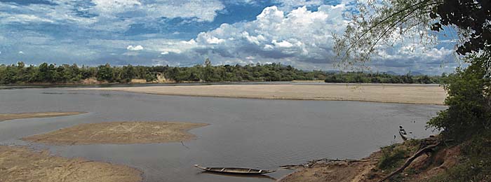
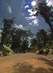
The northeastern province of Cambodia, bordering Vietnam and Laos is (or rather was? see below) widely covered with tropical rainforest. It is one of the last refuges of the Cambodian rain forests and for many animal species. Among them are wild elephants, gibbons and tigers who still live in the remotest parts of the jungle. The biodiversity here is among the richest in Southeast Asia.

Ratanakiri is not mountainous, rather coined by lowland rainforest and hills. Greater parts of it are under protection as the Lomphat Wildlife Sanctuary and the Virachey National Park. Alas, protection means little in reality. Illegal logging and hunting happens. Most of the illegal logging is done by Vietnamese loggers and the Cambodian military; the wood is then sold on Vietnamese markets.

Cho Ong Waterfall, Ratanakiri by Asienreisender

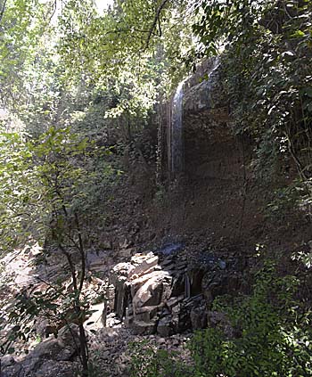
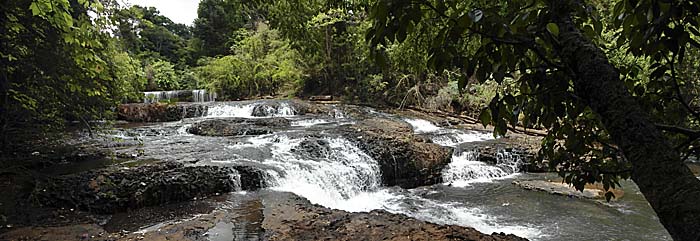
Cho Ong Waterfall, one of the 'natural attractions' of Ratanakiri. At the end of the dry season it's merely dropping. Image by Asienreisender, 2013

It's also home for 21 different tribal people of the Khmer Loeu group. Famous for them are their graveyards. Unique wooden statues are erected at the graves. The graveyards are kind of 'taboo' and it is not advisable just to go there for a visit. It's better to speak with the village chief of the local people first and make an arrangement for a visit.

Ratanakiri Province is sparsely inhabited. The 150,000 people living here are only a bit more than 1% of the total Cambodian population. The region is among the lowest in terms of modern development, including health care, education, other infrastructure. 75% of the population are illiterate and according to statistics 23% of the children die before getting five years old. A greater part of the population has no access to clean freshwater.

Also famous are the zircon mines in Ratanakiri Province. The active mines are about 35km east of Ban Lung. Hundreds over hundreds of small holes are drilled some 12m deep into the ground to dig out the semi-precious stones. Ratanakiri is translatable to 'hill of the precious stones', and refers to these gem mines around Ban Lung.

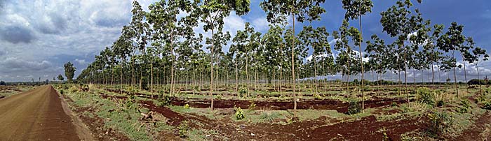
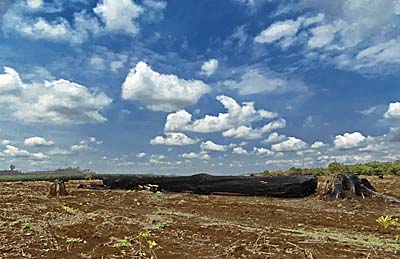
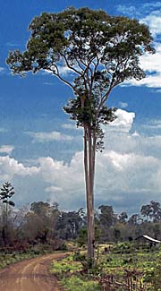
Since the 1960s the cultivation of rubber happens here. In the last decades deforestration for the sake of rubber and cashewnut cultivation is going on in an increasing speed. The tropical rainforest in this part of Southeast Asia is therefore as much under threat as the remaining forests elsewhere.

The agricultural products are not primarily for the domestic market but 'cash crops' for export.

Rain Forest in Ratanakiri by Asienreisender

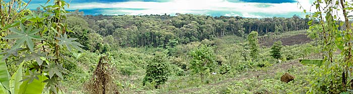
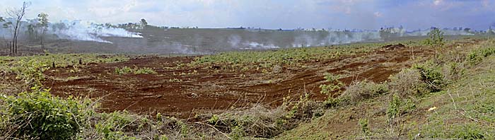
Remaining rainforest in the background, a slashed area in the foreground. Near the jungle road to Taveng. Image by Asienreisender, 2013

2.

History of Ratanakiri

The area of nowadays Ratanakiri is inhabited since more than 2,000 years, probably much longer. The early neighbouring high-cultures as the Cham and the Khmer (Angkor), later followed by the Laotians and Siamese came to the forested regions, but none of them brought it really under it's control. These invaders sent troops of slave hunters into the jungle to gain working slaves for their civilizations or to trade with the caught people. The slave trade ceased after the French colonial regime took over the region in 1893 from Siam.

After the independence, in the 1950s and 1960s, the Cambodian state initiated a Khmerization programme in order to further modernize this remote part of Cambodia. Tribal villagers should be brought under government control. Tribal people partially were forced to go to the lowlands for being educated in Khmer cultural patterns, while lowland Khmer People were settled down in Ratanakiri to extend the influence of the central state. Roads were built and larger plantations were made up. Local tribal people were also forced into corvee labour.

In 1968 it came to an uprise in which Khmer People were killed. The government reacted harshly and took severe revenge among the tribal people. Hundreds were killed, villages destroyed.

That background made the locals following the Khmer Rouge who took their headquarters in Ratanakiri in the 1960s. Vietnamese communists came over the border and turned the region practically being in a state of no more under control of the Cambodian government.

In 1969 and 1970 the Nixon administration authorized massive carped bombing of Ratanakiri to hit the Vietnamese activities. Nevertheless in the mid-1970s the central government couldn't keep control over the region anymore and withdrew all it's troops from the province, leaving it in the hands of the Khmer Rouge.

From that move on the Khmer Rouge became increasingly oppressive and abolished all cultural habits of the tribal people who were not conform to their communist concepts. That included not only religious traditions but the native languages as well. As later everywhere in Cambodia all schools were closed. Political 'cleansing' activities of the Khmer Rouge led to a killing of 5% of the population who ended up in mass graves. Thousands fled over the borders to Laos and Vietnam.

After the Vietnamese army defeated the Khmer Rouge in 1979 many Khmer Loeu came back. The Vietnamese neglected Ratanakiri and there was no real government. Under these conditions the Khmer Loeu could find back to their former livestyles. Though, until the 1990s there were still Khmer Rouge guerillas in the wide jungles of Ratanakiri.

After the ceasing of Khmer Rouge guerilla fight the present phase of Ratanakiri's history began. The government built first roads, improved the infrastructure, encouraged tourism and promoted the monoculture agriculture which is expanding more and more now. More lowland Khmer came and settled down here.

Land speculation started and the central government gave concessions to big investors or sold the land with all the side effects: corruption, cronyism, threats, deceptions... The province is also a big playground now for international NGO's (non-governmental organizations). The indigenous people here, who before actually 'owned' respectively farmed the land communally before, weren't asked.

Deprivation, the shift of traditional lifestyle and the loss of old values and habits are the consequences of a totally changed environment, together with resettlement into new-made villages.

A young Plantation in Ratanakiri by Asienreisender

A young rubber plantation. Image by Asienreisender, 2013

3.

Ban Lung

The little place of Ban Lung is Ratanakiri's province capital and the central place in the province. All the other places in Ratanakiri are merely small villages. Ban Lung itself is, as so many towns in Cambodia, completely in a process of re-construction. One can barely believe what's going on here for a change when not seeing it with own eyes. All the buildings around the central market place and the chessboard pattern street net around are new, many are still under construction. New roads are built in all directions, seamed with more building sites. Also a number of new hotels shot up very recently. The boom is obviously expected to last long and more tourists and businesmen are supposed to come.

The road connecting Ban Lung with Stung Treng is also new and in a good state. As I heared it's also built by Chinese investors, as the bridge over the Sekong River at Stung Treng and the new bridge over the Mekong River there.

Ban Lung's new Bus Station by Asienreisender

The new bus station in model and under construction. It's a bit more than 2km out of town. Seems that Chinese investors are dominant in the traffic sector. Images by Asienreisender, 2013

The electricity system is not very stable; when there are strong thunderstorms electricity sometimes fails in the whole town. The new hotels are therefore equipped with an emergency generator. Also the internet connections fail often for hours or a day or more. In fact it's remarkable that these facilities exist and are in a relatively good shape, considered that the place was so cut off from the rest of Cambodia until a few years ago and technical experts are rare.

There is also an unpaved airstripe in Ban Lung, but at the time there is no traffic. Probably it will be improved in the future.

The market place looks oversized compared to the town. It's not only attracting the town's people but the villagers in a wider surrounding, if not the whole province. It's among the dirtiest places I have seen. Particularly around the food stalls the dirt and rubbish left from the market activities is piled up and produces myriads of flies who come over the food and all the tables and equipment of the nearby restaurants. There is no waste-disposal solution in Ban Lung, and the amount of litter is increasing.

Ban Lung, Ratanakiri, Market Place by Asienreisender

Ban Lung's market place in the center of the town. Image by Asienreisender, 2013

4.

Between Stung Treng and Ban Lung

On the 85km new asphalt road between Stung Treng and Ban Lung are already wide areas of recent slash-and-burn to see. Partially it's very recently done, in this recent dry season probably, and yet nothing done to further use the land. Other parts are already transformed into plantations, rubber mostly. Many of the plants are very young, between one and five years. Then again, some parts have been burnt down a time ago and weren't farmed after, so that a first secondary jungle starts to grow up again. Here and there, particularly on the hills, are isolated remains of the original forest.

The road is completely paved. That means a quicker access for the industries on the natural surroundings. The road splits up into many sideroads who lead further into the new plantations and the forests. They are all dirt roads.

Aside the main road is a bigger building site for a new rubber factory.

Slash and Burn between Ban Lung and Stung Treng by Asienreisender

Slash and burn at the roadside. Image by Asienreisender, 2013

5.

Southeast of Ban Lung

When leaving the main road from Ban Lung to the Vietnamese border and turning right to Yaklom crater lake, one can follow the dirt road passing by the lake for many kilometers into the huge plantations. It all shows the same picture. Recently the tropical rainforest fell for the sake of huge plantation monocultures. Everywhere the traces of the fallen forests are to see. Even a lot of big trees who presumably could bring several thousand dollars per piece are only cut and burned. Maybe they were hurt by fire before already and lost their market value. In the surroundings here and there are columns of smoke to see. The burning is going on. Most of the plantations are still young, some are just planted. It's mostly rubber here, sometimes cashewnut.

Slash and Burn in Ratanakiri by Asienreisender

A former jungle giant, cut and burnt. The deforestation is followed by soil erosion and the change of microclimates. Image by Asienreisender, 2013

A few villages appear at the roadside. That's newly erected places for Khmer Loeu tribal people who formerly lived in the jungle. After the natural surroundings disappeared, they have been replaced into new villages with new, wooden houses. The villages here are dirty beyond description. Masses of plastic and organic waste is around, the foodstalls are plagued by myriads of flies. It's a NGO paradise here, guiding the displaced, deprived tribal people into their new lives of micro-credit based buisnesses, working for the big agricultural companies and blind consumption. It immediately starts that the kids drive motorbikes to overcome a few meters inside the village. It's a brave new world...

There are a very few islands of tropical rainforest left, very much in contrast now to the new environment. That's small places of a certain economic usability for tourism. It's also a compromise for the indigenous people because they believe these places, mostly spots with waterfalls, were holy places inhabited by spirits. Now they are allowed to make small business here, by selling entrance tickets and food and drinks.

There is the Ou'Sinlair Waterfall for example. It's a cascade of a jungle river providing some pools where tourists can have a bath. Piles of rubbish and the meanwhile familiar masses of flies are around there and give Ou'Sinlair Waterfall the charme of a waste disposal site. Some local tourists with their families enjoy a bath and lunch here and leave the rubbish.

Ou'Sinlair Waterfall, Ratanakiri by Asienreisender

Ou'Sinlair Waterfalls respectively rapids, in one of the few remaining pockets of rainforest. Image by Asienreisender, 2013

6.

Yaklom Lake

A similar picture presents Yaklom Lake, the famous crater lake very close to Ban Lung. It's actually in walking distance, some four kilometers from the town center only. The lake is around 700,000 years old and the result of a former volcanic caldera. The area near the main entrance appeared pretty crowded on a working day already. Propably there are more people on weekends and holidays.

Yaklom is surrounded by a small track close to the shore. Here it's quiet and few people walk around the lake. Since the lake is not big it's a short walk around.

There is also a 'cultural museum' at the seaside. In fact it's a smaller wooden building with very few artefacts inside, mostly drums, accompanied by a very few pictures.

In contrast to Ou'Sinlair the place is fairly clean.

Yaklom Crater Lake, Ban Lung, Ratanakiri by Asienreisender

Yaklom crater lake. Image by Asienreisender, 2013

7.

Taveng

Some 55km north of Ban Lung is Taveng, an older tribal village at the banks of the Tonle San (San River). The connection between Ban Lung and Taveng is leading over mostly a dirt road through what was formerly tropical rainforest. Now it's widely deforested, also here are merely remains of the primary forest left, mostly on hills and slopes again. From a few points of the road there is a good view over the landscapes. While southeast of Ban Lung is mostly rubber monoculture established, here it's mostly cashew nut.

The first few kilometers from Taveng are a paved road, after a crossing (right turn) it becomes a dirt road. That means on a two-wheel vehicle one has to swallow a lot of dust which is produced mainly by bypassing pickups and sometimes, more heavy but not so often, by lorries. Other motorbikes put a little on top of it.

The car drivers love to use their horn, and having done that they seem not to feel anymore responsible for the consequences of their driving style. They cut the curves and if a two-wheel driver is coming against he has to care. They are in the stronger position and that's enough justification for driving as they please.

After some more kilometers, at a village where the road splits the car traffic almost ceases. The road is passing through a hilly landscape with a few steeper passages. That's no problem so long the road is dry, but it gets dangerously slippery after a rain shower. A motorbiker can drive then only very slowly and carefully. Some fords are bridged with rough bridges make of wooden planks. One way of the trip can be driven in a time between 90 to 120 minutes so long it's dry.

Taveng by Asienreisender

Taveng's main road. Image by Asienreisender, 2013

On the way to Taveng are a few tribal villages as well, who look much better than the shabby places southeast of Ban Lung. Taveng itself is a small place. There are some simple restaurants, neighbourhood shops, a school, a few workshops, and a police station which appears disproportionate big. The banks of the Tonle San are scenic.

Tonle Sap, Sap River by Asienreisender

The Tonle San (San River). Image by Asienreisender, 2013

Asienreisender Up to the top!

Published on May 4th, 2013

131

Asienreisender