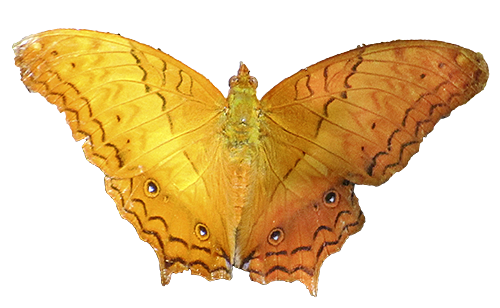
Chanthaburi
Chanthaburi is another province capital and province in east Thailand. In administrative terms it's part of central Thailand. The name is a sanskrit derivate and means 'moon city'. The province borders to the Gulf of Thailand, the city itself lies some kilometers away from it's shores at the bank of Chanthaburi River.
Inner Town
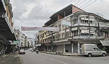
Booming Chanthaburi is coined by these typical concrete buildings. The old, wooden buildings have almost completely disappeared. A few of them are still existing, mostly along the banks of Chanthaburi River, but many are run down and in a bad shape. Image by Asienreisender, 8/2015
The Province of Chanthaburi is bordering Cambodia. There is a border crossing at Ban Phakkad (Thailand) to Psar Pruhm in Cambodia. That is an alternative route on the way to Battambang (via Pailin) for those travellers who want to avoid the notorious border crossing at Poipet.
The border between the both countries leads through the Cardamom Mountains. The highest peak in Chanthaburi Province is that of Khao Soi Dao Tai (mountain) with an altitude of 1,633m. From the mountains the landscapes lower down to the shores of the Gulf of Thailand. Chanthaburi city lies close to the feet of a high mountain ridge. It's well to see from some open places in the city and creates an impressing panorama.
Khao Soi Dao Tai Mountain
The highest peak in the mountainous Khao Khitchakut National Park. The weather is changing quickly in the mountains, and the mountain massive is particularly in rainy season often covered in clouds and fog. Image by Asienreisender, 8/2015
East of Chanthaburi lies Trat Province with it's border to Cambodia at Koh Kong.
The city has, according to official numbers around 28,000 inhabitants. However, the place looks too big and compact for so few people. In the province live estimated 528,000 people.
The local climate is classified as tropical monsoonal.
Chanthaburi River
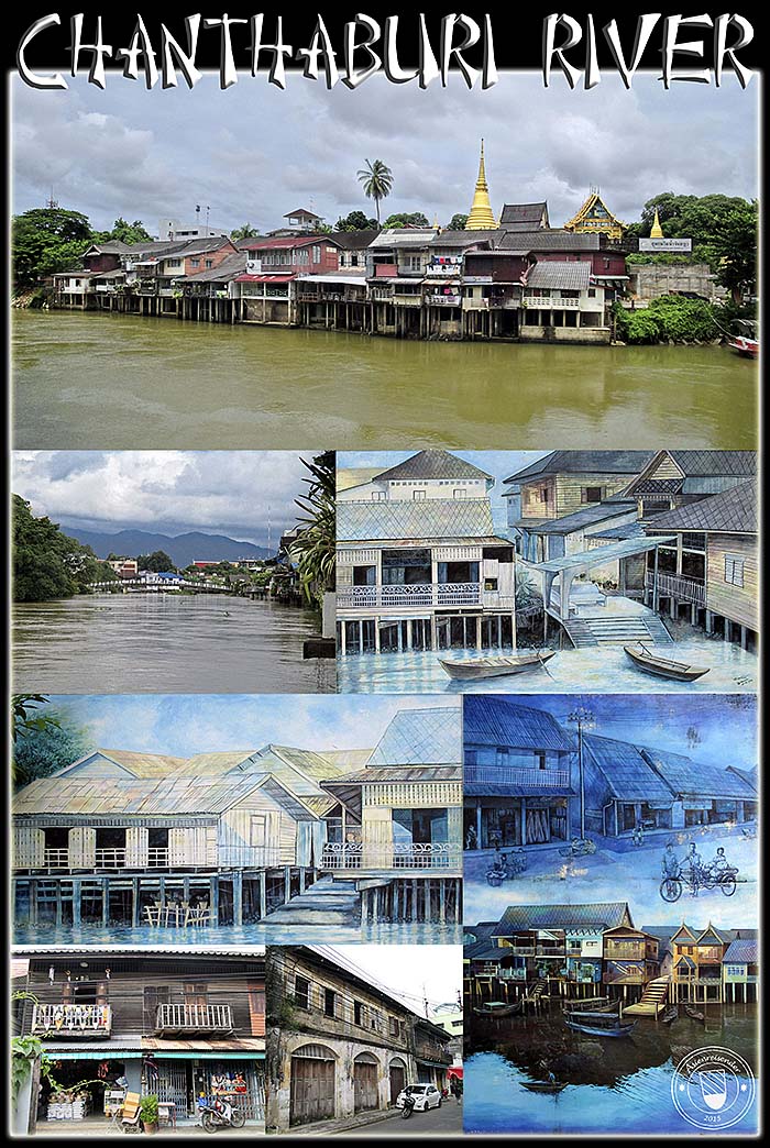
Humans need water. Settlements are preverably founded along rivers. Rivers serve as water supplies, as water ways and provide food. The climate along a river is pleasant. Breezes of fresh air moderate the tropical heat.
The oldest part of Chanthaburi lies therefore along the river banks. One can still see a number of the old, wooden buildings along Sukhaphiban Road. It's the center of Chanthabun Community which preserved what of it's tradition what can be called nostalgic now. But, the old Asia is dying. The old houses rot away and are more and more replaced by new concrete buildings who look often sad and faceless. However, here it's a stretch with some cozy and spaceous restaurants and cafes with terraces at the river bank. Some of the buildings are restored and look very fine.
The second image shows Niramon Bridge, what was built in 2005. The image right of it shows the old pier which was removed then for the bridge's construction. The paintings are on the walls of the buildings near the bridge. Niramon Bridge is a bridge only for pedestrians and connects the inner city on the right side of Chanthaburi River with the 'Cathedral of the Immaculate Conception' on the other side.
All images and photocomposition by Asienreisender, 8/2015
Traffic
Traffic Jam
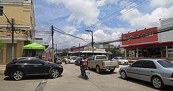
No walk in Chanthaburi without being permanently harassed by motorized vehicles. The roads are jammed with cars and motorbikes. The sidewalks are often insufficient and crammed with merchandises, rubbish or parked vehicles who make them impassable. The number of cars alone must have been quadrupled in the last five years. One sees barely an old car anymore; almost all of the tin on wheels is brandnew. Image by Asienreisender, 2015
The traffic in and around Chanthaburi is quite heavy. Thailand's roads have been filled with new cars and motorbikes in the last years. Particularly the Shinavatra goverment (2011 - 2014) promoted cheap loans for people who wanted to buy a new car. The economy was boosted for a few years; now it's no more running that well, and many people have a problem with their debts. The traffic boom means here in detail that it is very noisy, the fume smells and it is pretty difficult to cross a road. At least, and that helps a lot, take the drivers here care and let a walker go. They slow down often in advance and show so that one can walk safely.
Many of the streets in Chanthaburi are one-ways. For a stranger it's not always that easy to find a way back, for one is led into different directions and has to reorientate. It means also big detours in all the traffic, what is increasing the traffic as a whole. Still, there are not many redlights in town. At rush-hour one sees here and there a traffic policeman with a whistle. These whistles are extremely noisy in a high tone. Certainly no fun for the people who live close by.
The broad Sukhumvit road, a highway which starts in Bangkok and leads along the southern coast to Trat, is running along Chanthaburi. Other broad roads are connected to Sukhumvit around town. That spins a web of a huge motorway landscape around. There must be dozens of kilometers of three or four lanes highways. They are flanked by mostly industrial buildings and smaller roads split from them. The massive asphalt, the speeding on the big roads and the naked concrete of the buildings left and right are a real modern nightmare.
Road 317, which leads to the north parallel to the Cambodian border, is for the first kilometers also very wide. Further north, close to the junction to Ban Phakkad, it's under massive expansion. Another heavy impact for the nature and wildlife; west of the road is Khao Khitchakut National Park, right of it stretch the Cardamom Mountains. Also here is much traffic.
See also: Traffic in Thailand.
The Landscapes of Chanthaburi
There are four different types of landscapes in Chanthaburi Province. Besides the noisy city with it's urbanized concrete and asphalt architecture, which is widely designed for automobiles and commerce, there are three more. Most of the province's acreage is certainly the plains. Formerly tropical lowland forest, they have been transformed in the last few decades into plantation economy. Most of that would be rubber plantations, followed by fruit plantations of different kinds and pepper. In all my excursions through the province I notably haven't seen a single rice paddy. Rubber competes with food. Cars eat men.
A Jungle River
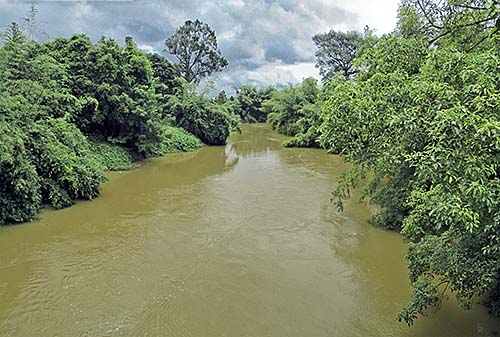
A tributary of Chanthaburi River. Image by Asienreisender, 9/2015
Around in the plains are several mountain massives scattered. They appear like forested islands in the lowlands. Since the steep mountain slopes are not so easily accessable for the industries and road construction, they are yet widely spared from destruction. Covered with tropical rainforest, for the bare eye they look still intact. Some of them are under protection and have national park status. What I saw from the parks gives a good impression to the visitor; it looks tidy and clean. However, the nature here is under pressure as well. And it would be naive to believe that the pressure wouldn't grow.
The mountains are the source of many streams and rivers who crisscross the province. The biggest of them is Chanthaburi River.
All the rivers flow towards the Gulf of Thailand. Chanthaburi Province has a long coastline along the Gulf. The coast in coined by mangrove forests, sand beaches and rocky cliffs. Two large bays interrupt the coastline and reach deep into the coastal lowland. They are the mouths of rivers and form a typical mangrove habitat. The coastal sections with the beaches are widely exploited by the tourist industries. Namely Laem Sing and moreover Chao Lao Beach are pretty touristic.
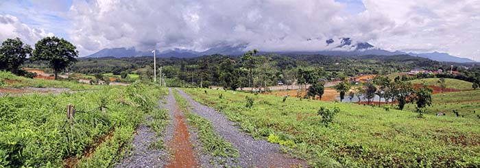
Plains and Mountains
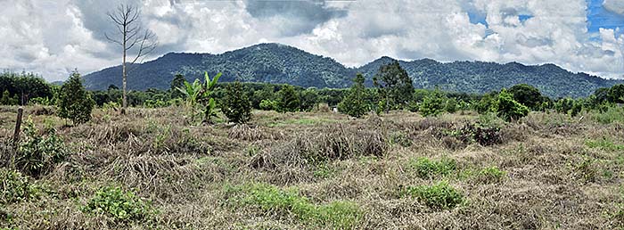
The plot in the foreground will be planted soon. In the middle are fruit plantations already and in the background lies one of Chanthaburi's mountain ridges. Image by Asienreisender, 9/2015
Namtokphlio National Park
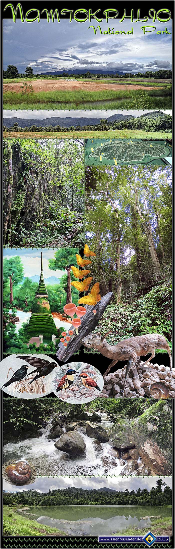
Very close east of Chanthaburi lies a mountain massive which is well to see from open places in the town as well as from around like from Laem Sing for example. The massive is covered with tropical rainforest and has the status of a national park since 1975. The altitude is varying between 300m and 924m, which is the peak of Khao Krok. Altogether covers the park an area of about 135km2. There are several entrances to the park. Most of them have guardhouses and entrance is charged.
Namtokphlio National Park is a refuge for a number of seldom animals, among them bears, gibbons, langures, pangolins, hornbills (alltogether 90 different bird species), deer and many more. The mountains are the source of many streams who form some bigger waterfalls. Thai People very much like waterfalls, so they are always local attractions.
In 1874 Siam's king Chulalongkorn visited Phlio Waterfall in company with queen Sunandha Kumariratana. Two years later the queen died. For her remembrance was a chedi built near the fall in 1876. In 1881 'Phra Nang Ruea Lom Stupa' was erected, where the remains of the queen are buried. These two constructions are places of worship for many Thai People. Phlio Waterfall is about 14km out of Chanthaburi and accessable via a sideroad of Sukhumvit Road.
All images and photocomposition by Asienreisender, 9/2015
Khao Khitchakut National Park
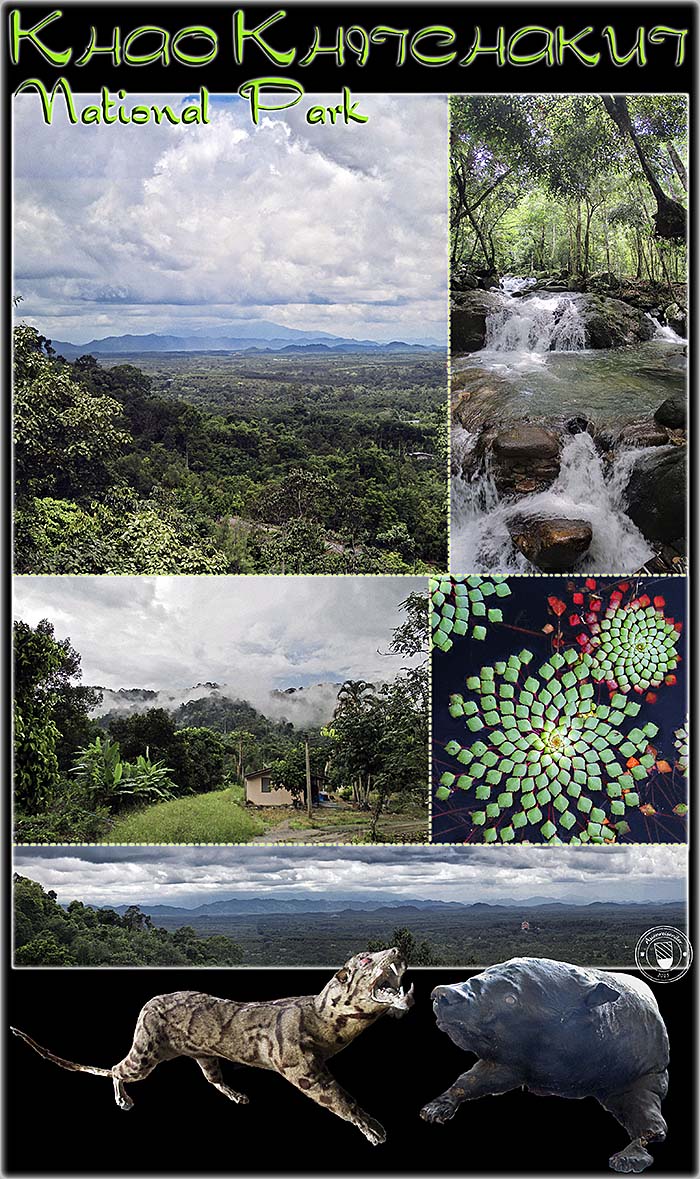
Some 15km north of Chanthaburi Town lies another mountainous national park (park status since 1977). Khao Khitchakut is coined by it's steep, forested slopes. The whole mountain massive has a bit of a boomerang shape. Although the general alignment of Southeast Asia's mountain chains is very mostly in a north-south direction, Khitchakut bends in it's northern half to the west. It is one of the barriers for the heavy clouds of the southwest monsoon who get queued here and rain down before lifting and been blown further to northeastern directions. It is also a watershed in the province and the source of many streams of who some flow together and form Chanthaburi River.
One of the sights here is Namtok Krathing (Krathing Waterfall). The stream is falling from a considerable height over thirteen cascades. In the middle part it is falling free for a few meters. In Thailand cascading streams are always called 'waterfalls', although a waterfall in it's proper meaning is water in free fall. Here one can climb up the mountain parallel to the fall. It's a small, very steep and in rainy season slippery path inmiddle of dense (secondary) forest with much bamboo. It requires some skills and a good shape to go up, for there are no steps and no supporting ropes. No signs either, so one has to care for finding the way back. Cost me a lot of sweat to do the climb. Later, being down again with a thoroughly soaked shirt, the climate proofed to be surprisingly chilly for the tropes.
The park entrance there consists of a small asphalt road with a parking, a headquarter, a restaurant, visitor toilets and a couple of houses for daily rent. A lake is there and the whole setting appears very tidy and clean. At the shores of the nearby lake are some pavilions where I could make up my hammock and spent some time. It's a very peaceful and pleasant atmosphere. Very few people were around.
There are more paths into the rainforest and other waterfalls. The peak of Khao Khitchakut is a longer walk. There is one of the alleged Buddha footprints who attract pilgrims in the dry season. Huge rock formations are another attraction there, together with a spring whose water shows a yellow colour (probably sulphate) and has the recommendation of healing qualities.
The mountain ridge and the national park are a refuge for many animals. The surrounding lowlands are all transformed from tropical rainforest into plantation economies. Every few kilometers a village appears. The plantations crawl close to the slopes. This loss of habitates caused without doubt a large extinction of many species. The mountains here are, despite their protection status, vulnerable to poachers and gatherers of plants and maybe even illegal logging and industrial impact.
Among the here living animals are dozends of bird species, deer of several kinds, gaurs, pangolins, langures and many other; even wild elephants and tigers are allegedly living in the remote parts of the park.
In the large and new Wat Khao Sukim, where the photo top left was shot from, is a collection of preserved animals of the region displayed. The wildcat and the bear are two of them.
All images and photocomposition by Asienreisender, 9/2015
The Coastline of Chanthaburi
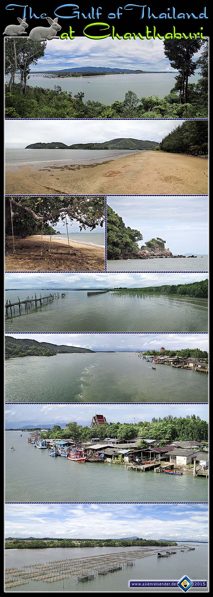
The coastline of Chanthaburi Province stretches over a few dozen kilometers along the Gulf of Thailand. Threre are several beaches, forested mountains and sections with mangrove forests. The beaches are touristic, but few Westerners come here; mostly Thai tourists and maybe some from other Asian countries.
The first two photos show the beach of Laem Sing and the bay behind. A long concrete bridge spans over the bay. Laem Sing has a small harbour with many local fishing boats. The beach is seamed with casuarina pine trees. There are many beach restaurants. The two photos below with the swings show Ao Khra Thing, a hidden beach, maybe the nicest place along the coast.
At one point is mangrove reforestation ongoing. Mangroves protect the coastline from storms and floods and are a very fertile habitate for a lot of species. Many people along the coast live traditionally from the sea, and there are many fishing boats and fisheries. Probably the sea here is as overfished as it is usually the case nowadays where fishing communities are. Worst are the big trawlers who come from outside and destroy the fishing grounds badly.
The most touristic beach is Chao Lao Beach with a kilometer long touristic infrastructure.
Images and photocomposition by Asienreisender, 2015
Economy

Local advertisment in a showroom window. Image by Asienreisender, 2015
The region is well-known for fruit plantations, among them pineapple, durian, rambutan, mangos and oranges. I even saw pepper plantations here. In all the excursions around in Chanthaburi Province there was no rice field to see. But, instead, there are many large rubber plantations in the area.
More particular for Chanthaburi are the gem mines. Rubies and red sapphires are produced and polished here. There is a quarter in the city where jewellery shops are concentrated. The jewellery street Thanon Si Chan is maybe the most popular of it's kind in whole Thailand.
Nowadays gem mining isn't anymore that intensive as it was in former times.
Remarkable is the high number of black people in Chanthaburi. Usually one sees very seldom people from Africa in Thailand. There is a gemstone trade with gems from Guinea. Since the mines around Chanthaburi are no more very productive, there seems to be a market for gems imported from abroad.
Chanthaburi is not a touristic place. Some tourists come here for an overnight stop on the way to nearby Koh Chang (Island).
Plantation Economy
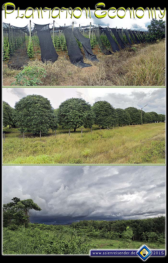
The large countryside of Chanthaburi is in the lowlands coined by plantation economy. A lot of fruits are growing here (those fruit trees on the middle photo are mangos), and there are also large rubber plantations. The French explorer Henri Mouhot visited Chanthaburi in 1859 (he called the place 'Chantaboun') and mentioned already pepper production.
Images and photocomposition by Asienreisender, 9/2015
History
The place is an old Khmer foundation. It's founding date is not exactly known; probably it dates back to the 9th century. In the 14th century Chanthaburi became part of Ayutthaya and played a role as a trade post and seaport. After the downfall of Ayutthaya, the local lord declared independence from Siam, but it lasted only short. After 1767 general Taksin (later Taksin became the first post-Ayutthaya king) conquered Chanthaburi and let the local nobleman executed. There is a martial king Taksin statue in Tungnachaey Recreation Park in the city. The statue was erected in 1893. Taksin used Chanthaburi as a headquarter until 1770.
General Taksin Monument & King Taksin Shrine
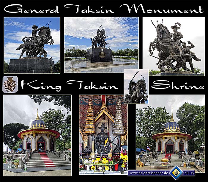
Taksin (1734 - 1782) was a Thai of Chinese decent. He became historically significant after the downfall of Ayutthaya and it's total destruction by Burmese troops in 1767. Taksin gathered remaining Siamese forces and fought against the Burmese in the west, while (re-)conquering territories in the north (Lanna) and the east (Laos and Cambodia). Taksin became the king of Siam in 1767 and founded a new capital at Thonburi at the banks of the Chao Praya River. Thonburi is nowadays a part of Bangkok. Taksin was succeeded by Maha Ksatriyaseuk (Rama I), the first of the Chakri dynasty.
The time immediately after the fall of Ayutthaya marks indeed a very desperate situation in Siamese history. The capital of the centuries old empire was complete destroyed, the king and significant parts of the nobility were dead, west and north Siam and also Lanna were repeatedly raided by Burmese invaders. One would actually assume that these disasters should have led to the extinction of the Siamese culture. It was by no doubt an extremely difficult task to gather and reorganize the remaining forces and sources, to found a new capital and to recapture and moreover expand lost territories under such circumstances.
King Taksin has been given the title 'the great' by the Thai parliament in 1981.
The Taksin Monument has been erected in 1893. The general's face expression is very martialic and determined, the whole ensemble shows dynamics. The Taksin Shrine has been built in 1920. It shows the king on a throne. The shrine's roof is built after the image of a royal hat with a pointed spire.
Monarchism is a pillar of the Thai state and palace propaganda is overwhelmingly everywhere in the country, as well in the public as in most of the private space. When I visit memorials of historic Thai kings it's usually the case that some Thai People are there for worship.
Images and photocomposition by Asienreisender, 8/2015
At the time of the Pak Nam Incident (1893) the place became occupied by French troops. It came back to Siam in exchange for neighbouring Trat and other western parts of Cambodia, namely Battambang and the Siem Reap region with the great temples of Angkor in 1905.
Tuek Daeng, the Red Armory
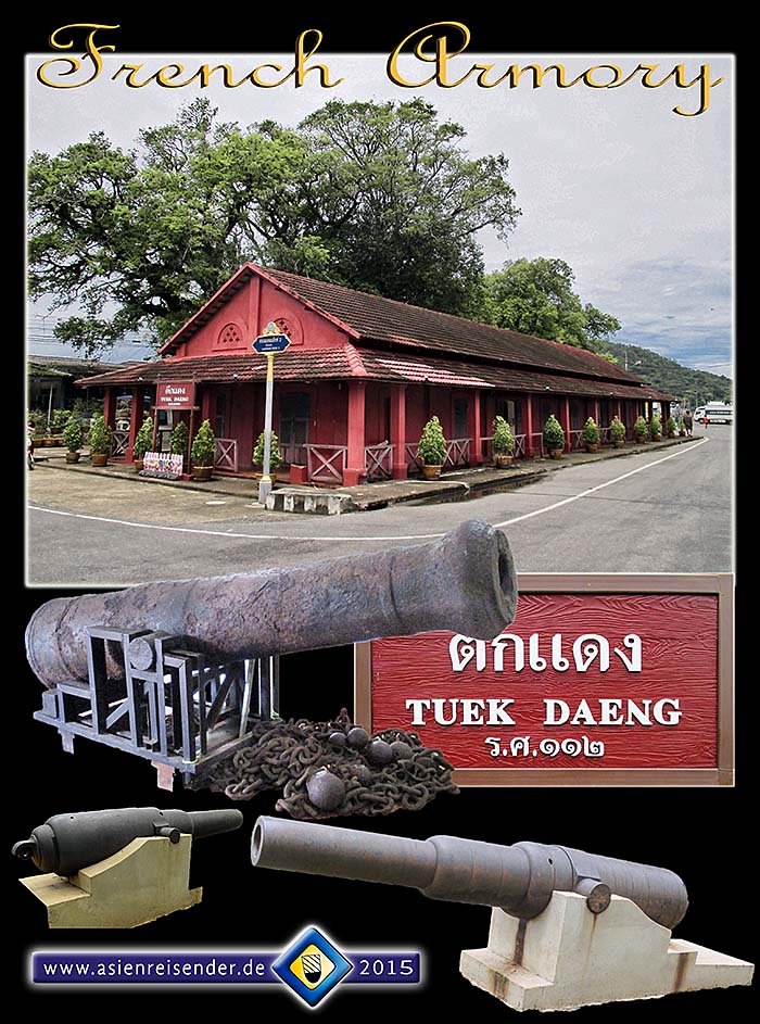
Chanthaburi Province has a long coastline at the Gulf of Thailand. One of the places at the coast is Laem Sing. In the short French time the colonialists had a garrison here. Near Laem Sing Beach is an old French armory with an ancient cannon. The building is well preserved and nowadays used as a small museum. There is not much to see insinde except a few information tables and the old, massive cannon.
The two cannons below are much more modern. They stand on a nearby hill on the other side of the long bridge over the bay. On this hill was once a fort; now there is a big buddhist stupa. A lot of macaques are around, frequently fed by Thai tourists.
Images and photocomposition by Asienreisender, 8/2015
There is a Vietnamese community in Chanthaburi. The Vietnamese here are by a great portion catholics. Vietnamese immigration happened in three major waves. A first wave left Vietnam during the anti-catholic pursuances in Cochinchina in the 19th century. A second wave came in the 1920s to 1940s and a third one after the end of the American Vietnam War. That's why Chanthaburi has a unusually large christian community. Very unusually for Thailand, there is the remarkable 'Cathedral of the Immaculate Conception' built in Gothic style.
Cathedral of the Immaculate Conception
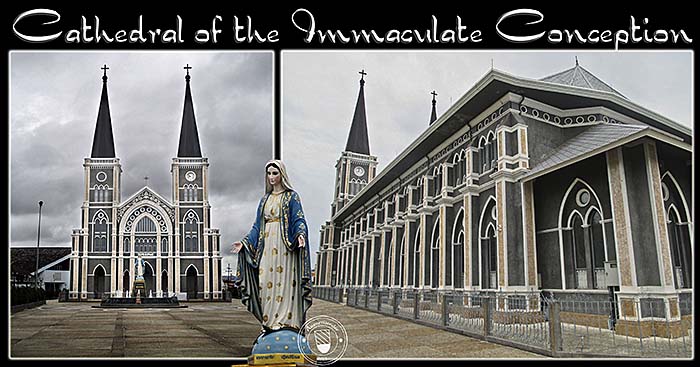
Do you believe in immaculate conception? Images and photocomposition by Asienreisender, 8/2015
A certain part of the population has Khmer roots. Their ancestors where brought here from neighbouring Cambodian territories by Siamese military forces as slaves in the 18th and 19th century. Meanwhile they are mostly assimilated and only about 1,6% still speak Khmer language.
Noen Wong Fortress
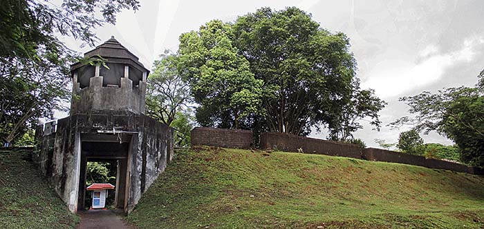
Noen Wong Fortress was built in 1834, in the early Rattanakosin era. It's function was to provide defence against Vietnamese invaders. 39 cannons were placed in the laterite walls. The material for the walls was taken from the older city walls of Chanthaburi. The fortress covers a huge area of more than 34 hectars. After the abandenment of the fort the walls collapsed partially. Now they are restorated.
Nowadays there are some people living inside the former fortress' walls. There is Yothanimitara Temple, which was built together with the fort, a city pillar shrine and a building of the fine arts department with specialization on underwater archeaology with a museum.
When king Taksin used Chanthaburi as a base there was a shipyard at the Gulf coast. A lot of artefacts of the time roughly around 1800 have been excarvated and are displayed here in the museum. The museum also shows sea routes and describes the life of the people of the time, which was based much on naval economy. Informations of the province's history are also displayed.
Image by Asienreisender, 8/2015