1.
The Cardamom Mountain Massive
The Cardamom Mountains (Khmer: Chuor Phnom Kravanh) are a more than two million hectars (20,000km2) large mountain massive in south and southwest Cambodia, stretching in small parts into east Thailand. It is still a last, spacious reserve of virgin tropical rainforest and untouched nature in the country with it's extremely high deforestation rate. The Cardamom Mountains are therefore home of a high number of rare wild animals and plants, of whom many are not yet discovered.
This mountain massive is, due to it's remoteness, by a great part still unexplored. It can be considered as one of the last great and in greater parts still intact ecosystems in whole Southeast Asia. About one million people are living in the area.
2.
Geography
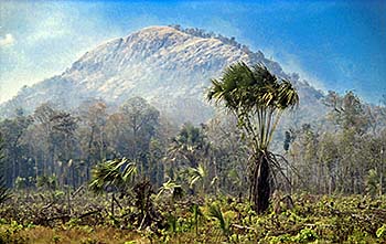
Geographically are the western parts of the Cardamom Mountains situated in Chanthaburi Province in Thailand. From there the mountains stretch over Veal Veng District towards southeast, comprising parts of Koh Kong Province at the Gulf of Thailand and reaching in it's southeastern offsprings as far as to the Elephant Mountains (the Damrei Mountains, see also: 'Bokor National Park') and even Phu Quoc Island in Vietnam. In it's length the mountains cover about 300km over a width of about 70km. The eastern slopes are at the Kirirom Plateau, Kampong Chhnang Province and in Pursat Province, where the mountains have a transition into the Cambodian plain and partially towards Southeast Asia's great lake, the Tonle Sap. The highest peak is Mount Aural (1,813m); Bokor Mountain reaches a height of 1,080m close to the Gulf of Thailand.
Bird Sounds
Bird songs in the jungle at the slopes of Phnom Kran (1,563m), Veal Veng. Audio by Asienreisender, 2/2016
Other high peaks are Phnom Samkos (1,717m), Phnom Tumpor (1,516m) and Phnom Kmoch (1,220m). These peaks are by distance the highest in Cambodia. The two eastern provinces of Ratanakiri and Mondolkiri, who are always described as mountainous, are rather hilly landscapes without high mountain peaks.
Larger parts of the mountains in the north and the Elephant range consist mostly of sandstone.
3.
Climate
The most dense tropical rainforests are located along the wet western slopes who get most of the rain of the annual southwest monsoon. I observed the heavy rains in Chanthaburi and Trat Provinces, where the humid winds enter the land, coming from the Indian Ocean, the Andaman Sea over the Gulf of Thailand. Much of the rain is coming down in the western parts of the mountains; Pailin for example lies already in a drier position at the lee side of several peaks. Rainfall at the eastern slopes is comparably far less, as for example at Kirirom Mountain.
4.
History
The geological history of the Cardamom Mountains dates back millions of years. The mountains and their tropical habitats are the result of an incredibly long development. Many of the region's species, both plants and animals, are unique, and many are still not discovered.
However, the human history in the region is a very short one. It goes not farther back than into the 15th century. A number of peculiar jars and coffins have been found and dated back to the centuries between the 15th and 17th, belonging to a unique culture.
After the Vietnamese occupation in 1979 the ruling Khmer Rouge bandits where driven out of the cities, but remained strong in many mountainous areas. Bokor Mountain, Kirirom Mountain, the area of Veal Veng and even the lower hills around Pailin were, due to their inaccessability, Khmer Rouge strongholds until the late 1990s. The Khmer Rouge were after 1979 actively supported by the USA, China and Thailand and supplied with arms, mines and other supplies, partly those who where under the UN aid and actually destined to be distributed among the Cambodian war refugees in the Thai border camps. Many of the areas have been heavily contamined with landmines in these years. Ironically, exactly these long-lasting struggles and the landmines helped to preserve the nature. With the clearance of the mines the way is free for human intrusion.
Now a place like Veal Veng is massively booming and expanding, and the locals do a great harm to the natural surroundings. Arson happens all the time during the dry season, logging of the largest and most valuable trees is following the establishment of new dirt roads into the jungle. New villages like Ou Soum are getting founded along new roads.
Also new dams like Stung Atai Dam do a great harm to the rainforests. Whole, large habitats are flooded, and the new lakes attract more people to live at their shores. The hydroelectricity producing dams need huge cable connections through the jungle. For that, long and broad corridors are cut into the forests. The destruction of the last tropical rainforests in Cambodia goes on in a rapid and seemingly accellerating speed.
A few international conservation groups are active in the Cardamom Mountains. Among them are the Wildlife Alliance who tried to conserve Bokor Mountain (without success) and launched in 2008 an ecotourism programme in the Areng Valley. However, 'ecotourism' turns most often out as ordinary tourist business labelled as 'eco' for marketing purposes.
Another, particularly active group is Mother Nature, who works on habitate protection in the Areng Valley. They particularly oppose the plans for another desastrous dam project on the Areng River.
5.
Ecology
The Cardamom Mountains, as a unique ecoregion, are geographically separated from other remaining rainforest habitats by the mostly deforested regions in east Thailand and the plain of the Chao Phraya River in central Thailand, by the Cambodian plains north and east of the mountains, further the elevated Khorat Plateau, and in the south by the Gulf of Thailand. The southeast is running out into a large plain between Kampot, Takeo and Phnom Penh with the Mekong River Delta.
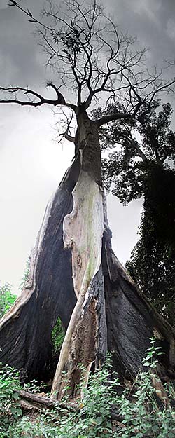
This jungle giant fell victim to a struck of lightning. Image by Asienreisender, around Veal Veng, 2/2016
Cambodia is a country which was still in the 1980s widely covered with tropical rainforest; estimations go up to 80% of the country's surface. Particularly since the early 1990s a rapid deforestation led to the total destruction of all lowland forests. Cambodia is therefore counted as the country with the fastest deforestation rate in the world. After the fall of the lowland forests, deforestation is gorging into the higher, more difficult to access regions of the country. Namely Cambodia's eastern regions of Ratanakiri and Mondulkiri have now been deadly affected by logging and arson. The tropical rainforests of the Cardamom Mountains are now the last reserve of untouched nature in the country, and they come increasingly under pressure. They get destroyed now even before being explored.
Most of the mountains are naturally covered with evergreen rainforest of a variety of different types, depending on the altitude and the amount of rainfall. Particularly remarkable is Kirirom Mountain with it's dense pine forests (pinus mercusii).
There is a rich wildlife in this region. Among the hundred or more mammals living here are the Indian Civet Cat, the Indochinese Tiger, the Clouded Leopard, Asian Elephants and many more. It's home for the Siamese Crocodile, the Sunda Pangolin and a great variety of birds, among them different kinds of hornbills; at the slopes of Bokor Mountain I saw repeatedly a larger hornbill. There I saw once also by distance the hugest millipede I ever saw - about 30cm to 40cm in lenght and quite thick. It's even said that two sweetwater species of dolphins are still living here, the Irrawaddy Dolphin and the Humpback Dolphin.
Among the here living animals are dozends of globally threatened animal and plant species.
A third of the Cardamom Mountain ecoregion has been declared protected area; in fact that means practically nothing, for there is no control and the authorities are that corrupt that they rather participate in the exploitation business. The Thai parts of the Cardamom Mountains have mostly been deforested until the 1980s already.
Tropical Rainforest in the Cardamom Mountains
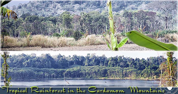
Dense, impassable tropical rainforest at the latest frontier of human encroachment. Images and photocomposition by Asienreisender, Veal Veng, Ou Soum, 2/2016
6.
Thmor Bang
The little district town of Thmor Bang lies in Koh Kong Province, already deeper inside the Cardamom Mountains. It's actually another fast growing village with a lot of plantation economy around.
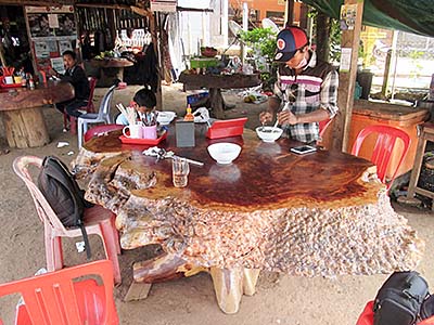
In one of Thmor Bang's restaurants. This huge table has been made from a giant jungle tree. It's bulky and impractical, and a severe loss for the forest. Such furniture are often to see in these settlements who gorge themselves into the nature. Image by Asienreisender, 2/2016
There are rubber plantations, pepper plantations, orange plantations, banana plantations and more. Deforestation happend over several kilometers around the place in all directions.
The place is surrounded by mountains at all sides. One dirt road, which leads east from the central and only roundabout, goes over a mountain ridge into the Areng Valley. Two other roads lead into other directions; one to Veal Veng and the other one I don't know where and couldn't further investigate because I had no motorbike. A broad and certainly newly made dirt road connects Thmor Bang with NH48 which leads westwards to Koh Kong.
There is one place to stay in Thmor Bang, what is Meang Chang Hong Guesthouse. It's a family-run, simple place with an attached banana plantation. I always saw only two women and a small boy there. They are supportive when one needs what and gave me at our good bye a bunch of bananas.
The Road to Thmor Bang
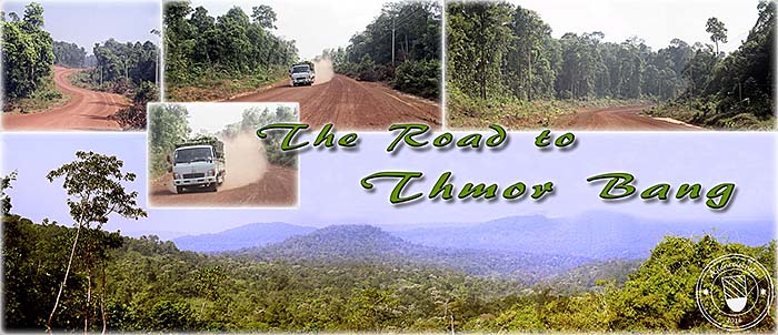
After splitting off NH48 the road to Thmor Bang leads for 33km through the rainforest. It's over all it's length that broad. When being on a motorbike, the first vehicle one encouters whirls such a dust up that one is thoroughly powdered and could need a shower and laundry.
It's apparent that this road will soon be paved and sideroads will follow. Urbanization guzzles it's way into the nature which is the result of a millions of years long development.
Most of the time one has no view over the surroundings, only at the last parts, when lowering down from the mountains into the valley of Thmor Bang, there are a few spots who grant a glance over the Cardamom Mountains. Images and photocomposition by Asienreisender, 2/2016
7.
Tatai Valley
The broad dirt road north of Thmor Bang leads through parts of Tatai Valley. It's a parallel valley to it's eastern neighbour Areng Valley, departed from it by a number of high mountains. Through Tatai Valley winds Tatai River. Further south of Thmor Bang, this river is dammed. Access to the dam is barred by a post with one or two of the typical bogeymen, of which the corporations here are so rich. Approaching the post, they block the road and exhaust most of their vocabulary: "NO!"
However, the dirt road to the north leads over some 18km through the valley. There is only one hamlet on the road, Puoch, before one reaches the road's next split at Tatai Leu. That's another very small place with just a fistful of shacks. Only one stone house I saw here, it's the sensation of the hamlet. From here a road continues to Ou Soum, what means a connection to either Pursat or even to the northern way out of the Cardamom Mountains at Pailin.
Tatai Leu is the place I actually tried to reach by walking from Chumna in the northern Areng Valley, but failed, because the track was not to find. It may be abandoned and, if still passable, only with a guide who knows the way. There won't be many.
Tatai Valley itself is green and less affected than Areng Valley by human impact, for the simple reason because there are not so many people living here. But nevertheless, as everywhere I came in the Cardamom Mountains, the nature is in retreat due to slash and burn.
Tatai Valley and Tatai Leu
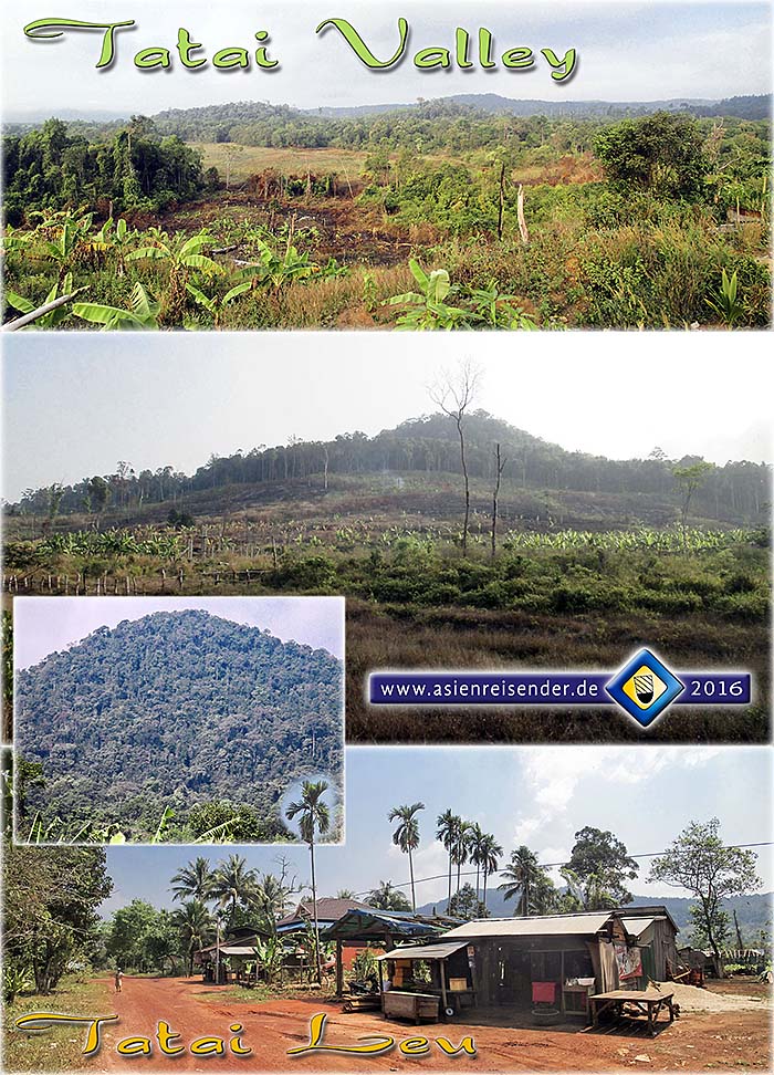
Tatai Valley and it's mountainous surroundings. The same sad picture like everywhere in the Cardamom Mountains. The air is filled with smoke. Day for day, slash-and-burn gorges more of the nature. The forest must die for the sake of somewhat so precious like bananas. The last image shows the center of Tatai Leu. Image by Asienreisender, 3/2016
8.
Threats
Logging, legal and illegal, slash-and-burn economies, arson, poaching, urbanization - that's some of the main threats for the nature in the Cardamom Mountains. Wildlife Alliance claims on their website that the Cardamom rainforests are among the most threatened in the world.
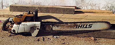
A STIHL motor chainsaw. An extremely effective tool to kill grand trees within an hour. Image by Asienreisender, Veal Veng, 2/2016
Building a whole new city on Bokor Hill Station inmiddle of Preah Monivong National Park is certainly not a 'green' project. A planned titanium mine which would have affected an area as large as 15,000 to 20,000 hectars was already approved by the government and construction started in secrecy. The project was cancelled in 2011.
Another severe threat are dams. Stung Atai Dam is running since about two years (according to an inofficial statement in 2/2016) and set a great part of the tropical rainforest under water. With the swelling lake came new squatters. Another desastrous dam is planned in the Areng Valley, which would destroy another large part of the nature and make a few thousand native Khmer Daeum People in the region homeless.
Human Encroachment
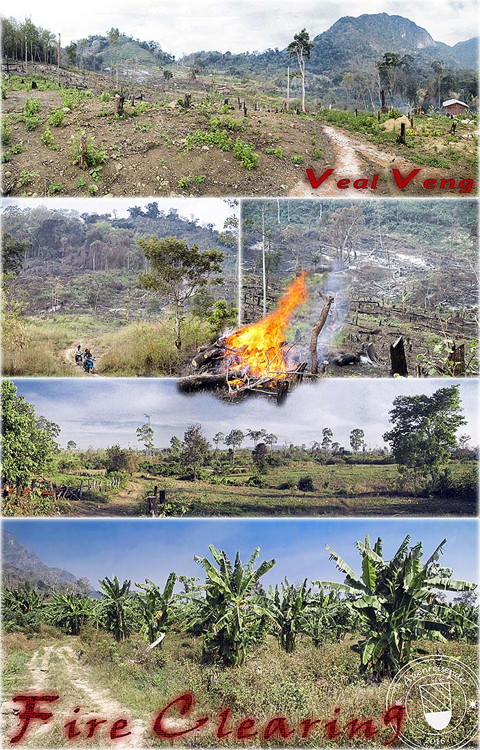
Arson, slash-and-burn, fire clearing - the rainforests are burning almost wherever I went. After the destruction the landscapes are changed into farmland. Remarkably many banana plantations get installed here in the mountains. Images and photocomposition by Asienreisender, Phnom Kran (1,563m), Veal Veng, 2/2016
The Cheay Areng Dam
One of the most remarkable areas in the Cardamom Mountains is the Areng Valley. It's a yet remote valley along the Areng River, bordered to the east and west by two high mountain ridges. The Areng Valley is mostly covered with tropical rainforest and a reserve for a few hundred species, of who 31 are critically endangered. This valuable habitate was in the last years the target of industries who planned first to built large-scale titanium mines in the mountains and then, after this project anyhow failed, the Cambodian government planned to built a dam there, destroying most of the tropical rainforests. It is due to the brave and intelligent resistance of a local activists group named Mother Nature, that the industrialization of the Areng Valley could be fended. However, the valley is still under pressure, and the dam construction will maybe happen in 2018, after the next elections in Cambodia.
For an elaborate introduction into the Areng Valley and the Cheay Areng Dam click the links...